


Welcome to Monroe County! Located in beautiful South Central Kentucky, we invite you to explore our natural beauty of the Upper Cumberland hills, the Cumberland River, the headwaters of the Barren River, great recreational opportunities, as well as the hospitality of a slower paced lifestyle of rural Kentucky. Turn off the main road into a small town environment with a rich heritage that offers many opportunities for the vacationer. Take any road... you won't be disappointed.

Monroe County Watermelon Festival
Monroe County Fair
Roller Coaster Fair
Monroe County Airport Fly-In

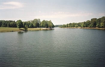 "Mill Creek Recreation Area & City Park" is just south of Tompkinsville. Located
next to a beautiful 113 acre lake which serves as the city's reservoir. From Tompkinsville take Hwy163
south For 1/2 Mile. Turn right onto Mill Creek Road and go 3 Miles, the park and lake is on
the right. This is very popular with local and visiting fishermen with several boat ramps
available. The park also features two shelters with playgrounds at both, picnic areas, tennis
and basketball courts, softball fields, and wooded areas for hiking and nature watching.
"Mill Creek Recreation Area & City Park" is just south of Tompkinsville. Located
next to a beautiful 113 acre lake which serves as the city's reservoir. From Tompkinsville take Hwy163
south For 1/2 Mile. Turn right onto Mill Creek Road and go 3 Miles, the park and lake is on
the right. This is very popular with local and visiting fishermen with several boat ramps
available. The park also features two shelters with playgrounds at both, picnic areas, tennis
and basketball courts, softball fields, and wooded areas for hiking and nature watching.
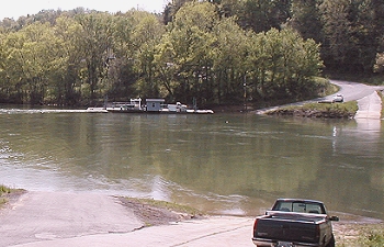 "Cumberland River Ferry" connects the two
segments of Hwy214, and it is the only ferry owned and operated by the Commonwealth of Kentucky. This once
was a two-car capacity barge-type ferry with a small tugboat to the port side of the barge attached by
means of a pivot. It was acquired by the state of Kentucky in 1968 from Cleo Finley. The ferry has been
and is still is the only means of crossing the Cumberland River for 30 miles. It leads to the
scenic Turkey Neck Bend area of Monroe County. The Cumberland River Ferry is one of the last
remaining free-floating ferries. Making several hundred trips across the river each day. The
ferry has become a vital part of travel through the area. There are boat ramps available. From
Tompkinsville take Hwy100 east for 5 miles. Turn right onto Hwy214 and go 2 miles.
"Cumberland River Ferry" connects the two
segments of Hwy214, and it is the only ferry owned and operated by the Commonwealth of Kentucky. This once
was a two-car capacity barge-type ferry with a small tugboat to the port side of the barge attached by
means of a pivot. It was acquired by the state of Kentucky in 1968 from Cleo Finley. The ferry has been
and is still is the only means of crossing the Cumberland River for 30 miles. It leads to the
scenic Turkey Neck Bend area of Monroe County. The Cumberland River Ferry is one of the last
remaining free-floating ferries. Making several hundred trips across the river each day. The
ferry has become a vital part of travel through the area. There are boat ramps available. From
Tompkinsville take Hwy100 east for 5 miles. Turn right onto Hwy214 and go 2 miles.
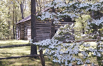 "Old Mulkey Meeting House State Historic Site" is just
south of Tompkinsville and preserves the oldest log meetinghouse in Kentucky, built in 1804 during a period of
religious revival. Many Revolutionary War soldiers and early pioneers, including Daniel
Boone's sister, Hannah, are buried in the churchyard. The log building also saw the
beginning of one of the largest denominations of the Christian religion ever organized.
The Old Mulkey Church was originally called the Mill Creek Baptist Church, established by
a small band of pioneer Baptists from North and South Carolina led by Philip Mulkey. John
Mulkey was the first preacher of record. In April 1804 the growing congregation commissioned
the building of a meetinghouse. This crude log structure, with puncheon floor, pegleg seats,
chinked and daubed walls, clapboard shutters and hand rived shingles, was built with 12
corners and in the shape of a cross with three doors. Many historians believe that the 12
corners represent the 12 apostles, while others believe that they represent the 12 tribes
of Israel. The three doors are symbolic of the Holy Trinity. From Tompkinsville take Hwy1446
south for 2 miles. The park is on the right.
"Old Mulkey Meeting House State Historic Site" is just
south of Tompkinsville and preserves the oldest log meetinghouse in Kentucky, built in 1804 during a period of
religious revival. Many Revolutionary War soldiers and early pioneers, including Daniel
Boone's sister, Hannah, are buried in the churchyard. The log building also saw the
beginning of one of the largest denominations of the Christian religion ever organized.
The Old Mulkey Church was originally called the Mill Creek Baptist Church, established by
a small band of pioneer Baptists from North and South Carolina led by Philip Mulkey. John
Mulkey was the first preacher of record. In April 1804 the growing congregation commissioned
the building of a meetinghouse. This crude log structure, with puncheon floor, pegleg seats,
chinked and daubed walls, clapboard shutters and hand rived shingles, was built with 12
corners and in the shape of a cross with three doors. Many historians believe that the 12
corners represent the 12 apostles, while others believe that they represent the 12 tribes
of Israel. The three doors are symbolic of the Holy Trinity. From Tompkinsville take Hwy1446
south for 2 miles. The park is on the right.
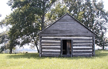 "Free-Town Church" was built in 1846 by freed slaves of William Howard, who gave them 400
acres on which to build homes, known since then as Free-Town. Albert Martin gave them the
land for the church. No replacements of the original building material of this church,
except for metal roof in place of old wooden one. The logs are held together by wooden
pegs and chinked with clay. From Tompkinsville take Hwy63 south for 7 miles to Gamaliel.
Turn right onto Hwy100 then go 2 miles, the church is on the left side if the road with a
state marker.
"Free-Town Church" was built in 1846 by freed slaves of William Howard, who gave them 400
acres on which to build homes, known since then as Free-Town. Albert Martin gave them the
land for the church. No replacements of the original building material of this church,
except for metal roof in place of old wooden one. The logs are held together by wooden
pegs and chinked with clay. From Tompkinsville take Hwy63 south for 7 miles to Gamaliel.
Turn right onto Hwy100 then go 2 miles, the church is on the left side if the road with a
state marker.
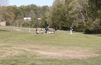 "Hidden Hills Golf And Country Club" is just south of Tompkinsville near the city park
and Mill Creek Lake. From Tompkinsville take Hwy163 south for 1/4 mile, Turn right onto Mill
Creek Road, go 1 mile and turn right onto Country Club Lane. This road will dead end at the
clubhouse. The course features rolling hills, Bermuda fairways, lots of trees, and favors
slicers more than hookers. Lightly trapped, with water on 6 holes.
"Hidden Hills Golf And Country Club" is just south of Tompkinsville near the city park
and Mill Creek Lake. From Tompkinsville take Hwy163 south for 1/4 mile, Turn right onto Mill
Creek Road, go 1 mile and turn right onto Country Club Lane. This road will dead end at the
clubhouse. The course features rolling hills, Bermuda fairways, lots of trees, and favors
slicers more than hookers. Lightly trapped, with water on 6 holes.
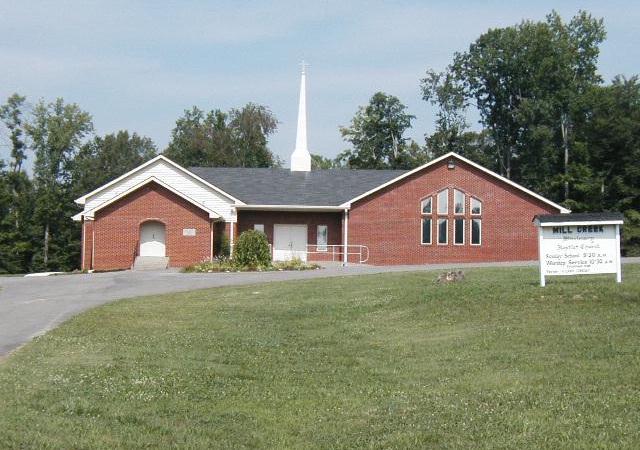 "Mill Creek Baptist Church" was named after the Old Mulkey Baptist Church in 1809. A large
congregation worshipped in the newly built Old Mulkey log meetinghouse beginning in 1804. A
controversy arose over the teachings of John Mulkey, which led to several heresy trials.
Failing to gain a majority vote against him, the church decided to choose sides. The majority
of the group that believed as Mulkey did continued to worship in the church. After the split,
it became known as "Old Mulkey." The other congregation built the second Mill Creek Baptist
Church on Mill Creek Road. From Tompkinsville take Hwy163 south For 1/2 Mile. Turn right onto
Mill Creek Road and go 3 Miles, the church is on the right.
"Mill Creek Baptist Church" was named after the Old Mulkey Baptist Church in 1809. A large
congregation worshipped in the newly built Old Mulkey log meetinghouse beginning in 1804. A
controversy arose over the teachings of John Mulkey, which led to several heresy trials.
Failing to gain a majority vote against him, the church decided to choose sides. The majority
of the group that believed as Mulkey did continued to worship in the church. After the split,
it became known as "Old Mulkey." The other congregation built the second Mill Creek Baptist
Church on Mill Creek Road. From Tompkinsville take Hwy163 south For 1/2 Mile. Turn right onto
Mill Creek Road and go 3 Miles, the church is on the right.
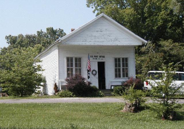 "Hestand Kentucky Post Office" The first Hestand Post Office was established in 1886. The
present structure was built by Joshua and served as a general store. It has been in the
Hestand (Baxter) family since 1886. The present owner, Mary Doyle Baxter Murphy, served as
postmistress for 26 years. The building has retained its original architecture, appearance,
and use since 1902. From Tompkinsville take Hwy 163 south 5 miles to the town of Hestand,
the Post Office is on the right.
"Hestand Kentucky Post Office" The first Hestand Post Office was established in 1886. The
present structure was built by Joshua and served as a general store. It has been in the
Hestand (Baxter) family since 1886. The present owner, Mary Doyle Baxter Murphy, served as
postmistress for 26 years. The building has retained its original architecture, appearance,
and use since 1902. From Tompkinsville take Hwy 163 south 5 miles to the town of Hestand,
the Post Office is on the right.
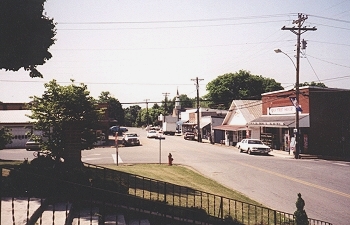
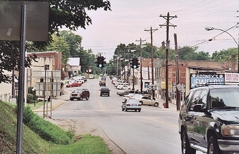 "Tompkinsville" is located in the center of the
county and was first settled about 1790, with most of the houses located on the western bluffs of Mill Creek.
The community was chosen the county seat when Monroe became a separate county in 1820, with a present
population of around 3000 people and home to the several famous Monroe County barbecue restaurants in
the area. Major highways into the town are Hwy 163 (from Edmonton north and Celina south),
Hwy 100 (from Burkesville east and Scottsville west), and Hwy 63 (from Glasgow northwest).
"Tompkinsville" is located in the center of the
county and was first settled about 1790, with most of the houses located on the western bluffs of Mill Creek.
The community was chosen the county seat when Monroe became a separate county in 1820, with a present
population of around 3000 people and home to the several famous Monroe County barbecue restaurants in
the area. Major highways into the town are Hwy 163 (from Edmonton north and Celina south),
Hwy 100 (from Burkesville east and Scottsville west), and Hwy 63 (from Glasgow northwest).
 "Fountain Run" is the crossroads of three counties,
located in the west corner of the county near the Barren and Allen county borders. The town features some
interesting old homes, business structures and storefronts. This is a community of around 300 people. It was
settled around 1800 by pioneers from North Carolina and Virginia. The community was first
known as "Jamestown" but the name "Fountain Run" was later taken from several large springs
in the area. Major highways into the town are Hwy 100 (from Gamaliel south and Scottsville
west), and Hwy 87 (from Barren River State Park northwest).
"Fountain Run" is the crossroads of three counties,
located in the west corner of the county near the Barren and Allen county borders. The town features some
interesting old homes, business structures and storefronts. This is a community of around 300 people. It was
settled around 1800 by pioneers from North Carolina and Virginia. The community was first
known as "Jamestown" but the name "Fountain Run" was later taken from several large springs
in the area. Major highways into the town are Hwy 100 (from Gamaliel south and Scottsville
west), and Hwy 87 (from Barren River State Park northwest).
 "Gamaliel" is located in the southwest part of the
county and became known as Gamaliel around 1835. It was named for a learned man of the bible. The area was
settled around the late 1700's and many of the current residents are the descendants of the early settlers.
Located near the headwaters of the Barren River the town is 1 mile from the Tennessee border. The
town currently has a population of around 460 people and has numerous homes of historical
and architectural interest. Major highways into the town are Hwy 63 (from Tompkinsville north).
"Gamaliel" is located in the southwest part of the
county and became known as Gamaliel around 1835. It was named for a learned man of the bible. The area was
settled around the late 1700's and many of the current residents are the descendants of the early settlers.
Located near the headwaters of the Barren River the town is 1 mile from the Tennessee border. The
town currently has a population of around 460 people and has numerous homes of historical
and architectural interest. Major highways into the town are Hwy 63 (from Tompkinsville north).
 "Barren River Lake State Resort Park"
is northwest of Monroe County and a water-lover's paradise surrounded by forested, rolling hills. The resort is
located near Kentucky's famous cave area, which includes Mammoth Cave National Park, the
longest cave system in the world. The Louie B. Nunn Lodge and the contemporary styling of
the park's 22 cottages overlooks the beautiful 10,000-acre lake. Great fishing at the
"tailwater" end of the lake below the dam. From Tompkinsville take Hwy100 south 2 miles.
Turn right on Hwy1366 and go 8 miles. Turn right on Hwy100 and go 6 miles to Fountain Run.
Then take Hwy87 north for 12 miles to the State Park entrance.
"Barren River Lake State Resort Park"
is northwest of Monroe County and a water-lover's paradise surrounded by forested, rolling hills. The resort is
located near Kentucky's famous cave area, which includes Mammoth Cave National Park, the
longest cave system in the world. The Louie B. Nunn Lodge and the contemporary styling of
the park's 22 cottages overlooks the beautiful 10,000-acre lake. Great fishing at the
"tailwater" end of the lake below the dam. From Tompkinsville take Hwy100 south 2 miles.
Turn right on Hwy1366 and go 8 miles. Turn right on Hwy100 and go 6 miles to Fountain Run.
Then take Hwy87 north for 12 miles to the State Park entrance.
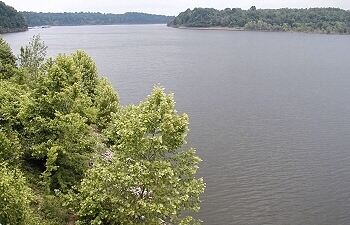
 "Dale Hollow Lake State Park" is
east of Monroe County and is a picturesque lake located north of the Kentucky/Tennessee border.
The dam is near the town of Celina, Tennessee and the lake is in part of three counties in
Tennessee, and two counties in Kentucky. The Lake is a deep cold water lake that offers the
angler plenty of challenges. It contains several species of fish and is known for some record
catches. From Tompkinsville take Hwy100 east for 5 miles. Turn right onto Hwy214 (Cumberland
ferry road) and go 8 miles. Then turn left onto Hwy61 for 5 miles. Then turn right onto Hwy449
for 2 miles. Then turn right onto Hwy1206 for 2 miles to the State Park entrance.
"Dale Hollow Lake State Park" is
east of Monroe County and is a picturesque lake located north of the Kentucky/Tennessee border.
The dam is near the town of Celina, Tennessee and the lake is in part of three counties in
Tennessee, and two counties in Kentucky. The Lake is a deep cold water lake that offers the
angler plenty of challenges. It contains several species of fish and is known for some record
catches. From Tompkinsville take Hwy100 east for 5 miles. Turn right onto Hwy214 (Cumberland
ferry road) and go 8 miles. Then turn left onto Hwy61 for 5 miles. Then turn right onto Hwy449
for 2 miles. Then turn right onto Hwy1206 for 2 miles to the State Park entrance.
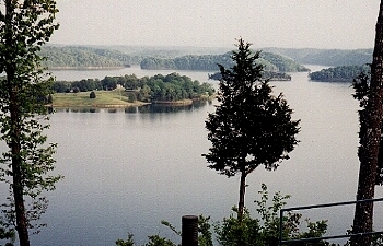
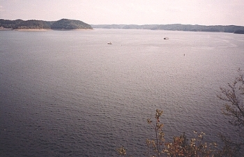 "Lake Cumberland State Resort Park"
is one of the finest fishing and pleasure boating areas in the Eastern United States. It
is also the largest 'man-made' lake east of the Mississippi River. The resort is a haven
for large deer herds and raccoon populations. Lake Cumberland is a paradise for the water
sports enthusiast. The marina offers 100 open slips, rental fishing boats, pontoon boats,
houseboats, and ski boats. With 50,250 acres, Lake Cumberland has an abundance of largemouth,
smallmouth, white and Kentucky bass, bluegill, crappie, rockfish, and walleye. The
construction of the Wolf Creek Dam was approved in 1938. It is one of the many units for
the comprehensive flood control reservoir system on the Cumberland, Ohio and Mississippi
Rivers. The Dam was constructed across the Cumberland River in Russell County. From
Tompkinsville take Hwy100 east for 5 miles. Turn right onto Hwy214 (Cumberland ferry road)
and go 8 miles. Then turn left onto Hwy61 for 12 miles to Burkesville. Turn right on Hwy90
for 15 miles. Then turn left on US Hwy 27 for 11 miles and cross Wolf Creek Dam then
continue for 2 miles to the park entrance.
"Lake Cumberland State Resort Park"
is one of the finest fishing and pleasure boating areas in the Eastern United States. It
is also the largest 'man-made' lake east of the Mississippi River. The resort is a haven
for large deer herds and raccoon populations. Lake Cumberland is a paradise for the water
sports enthusiast. The marina offers 100 open slips, rental fishing boats, pontoon boats,
houseboats, and ski boats. With 50,250 acres, Lake Cumberland has an abundance of largemouth,
smallmouth, white and Kentucky bass, bluegill, crappie, rockfish, and walleye. The
construction of the Wolf Creek Dam was approved in 1938. It is one of the many units for
the comprehensive flood control reservoir system on the Cumberland, Ohio and Mississippi
Rivers. The Dam was constructed across the Cumberland River in Russell County. From
Tompkinsville take Hwy100 east for 5 miles. Turn right onto Hwy214 (Cumberland ferry road)
and go 8 miles. Then turn left onto Hwy61 for 12 miles to Burkesville. Turn right on Hwy90
for 15 miles. Then turn left on US Hwy 27 for 11 miles and cross Wolf Creek Dam then
continue for 2 miles to the park entrance.
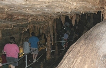 "Mammoth Cave National Park" has
with more than 350 miles of explored passageways, is the longest known cave
system in the world! This World Heritage Site and
International Biosphere Reserve supports several species of rare animal life and
many types of cave formations, with the formative process still active today.
All tours begin at the visitor center. During summer months, 11 different tours
are offered daily. Park rangers lead you to such sites as Frozen Niagara, Fat
Man's Misery, Bottomless Pit, and Grand Central Station. You'll also see
prehistoric artifacts and the 1812 saltpeter mining operation. The cave
temperature remains around 54 degrees, so dress appropriately. Above ground, there
are 52,830 acres of scenic protected forest lands for camping,
hiking, biking, fishing and horseback riding, including Big Woods, 300 acres of
old-growth forest. A number of other unique plant communities - hemlocks and
other northern plants growing in cool ravines, wetlands, and open barrens with
prairie vegetation - shelter many of the park's rare species. Almost 900 species
of flowering plants alone have been identified, with 21 of these endangered,
threatened or of special concern. Nearly 30 miles of the Green River and Nolin
River wind their way through the park and offer some of the best canoe runs in
the state. A ride on the Miss Green River II cruise boat is a great way to enjoy
the scenery and wildlife. Seventy miles of trails wind through the park.
Day-hiking trails are primarily on the south side of the Green River near the
visitor center. From Tompkinsville take Hwy163 north 13 miles. Turn left
on hwy90 for 27 miles through Glasgow to Cave City. Then cross over I-65 onto
Hwy70 for 5 miles to the park entrance.
"Mammoth Cave National Park" has
with more than 350 miles of explored passageways, is the longest known cave
system in the world! This World Heritage Site and
International Biosphere Reserve supports several species of rare animal life and
many types of cave formations, with the formative process still active today.
All tours begin at the visitor center. During summer months, 11 different tours
are offered daily. Park rangers lead you to such sites as Frozen Niagara, Fat
Man's Misery, Bottomless Pit, and Grand Central Station. You'll also see
prehistoric artifacts and the 1812 saltpeter mining operation. The cave
temperature remains around 54 degrees, so dress appropriately. Above ground, there
are 52,830 acres of scenic protected forest lands for camping,
hiking, biking, fishing and horseback riding, including Big Woods, 300 acres of
old-growth forest. A number of other unique plant communities - hemlocks and
other northern plants growing in cool ravines, wetlands, and open barrens with
prairie vegetation - shelter many of the park's rare species. Almost 900 species
of flowering plants alone have been identified, with 21 of these endangered,
threatened or of special concern. Nearly 30 miles of the Green River and Nolin
River wind their way through the park and offer some of the best canoe runs in
the state. A ride on the Miss Green River II cruise boat is a great way to enjoy
the scenery and wildlife. Seventy miles of trails wind through the park.
Day-hiking trails are primarily on the south side of the Green River near the
visitor center. From Tompkinsville take Hwy163 north 13 miles. Turn left
on hwy90 for 27 miles through Glasgow to Cave City. Then cross over I-65 onto
Hwy70 for 5 miles to the park entrance.


Website created and maintained by George Stewart/Rainman Graphix ©1998-2025
Send your comments or questions to webmaster@georgestewart.online